
I have been working on a history of the MRT in Singapore. The MRT is the local name for their “Subway”, “Metro” or “Underground” depending on where you are from, more generally known as Heavy Rail Public Transport. It is a very important part of the overall public transportation in Singapore; the government wants to convince people not to buy a car. To do this, they make the purchase of a car very (very) expensive and provide a cheap and convenient alternative in the form of excellent public transport and cheap taxis.
We do not own a car and therefore depend on busses and the MRT for most of our movements around town. When we made the decision, we also agreed that whenever necessary, or more convenient, we would just take a taxi; so far, there have been very few instances when we actually needed to take a taxi. All it takes is a little planning ahead, and leaving early enough.
I have been coming to Singapore regularly since 1996 and lived here for 8 years between 2000 and 2009; I have visited regularly since then on business, or more often for pleasure to see friends and family. I have seen the network grow at a tremendous pace; this can cause significant inconveniences as there are works going on everywhere, often affecting traffic and lasting for several years. I was discussing this pace of development with friends recently and they seemed very impressed so I decided to do some research and see just how dramatic the pace really was.
These are just some thoughts that I have gathered by reading various sites on Internet (Yes, I know, do not believe all you see on the Internet – so you need to use your own judgement with this document as well); the main sources I used are shown at the bottom of this post.
Let’s start with today. As of August 2022, this is what the network looks like:
I have to be precise on when this is valid as there is a planned expansion before the end of this year – more on that later.
As of August 2022, there are 6 lines and 127 stations – see the table below. There are also several LRT lines (or Light Rail Transport – in grey on the map above) that bring people from larger neighborhoods to the nearest MRT station. These are not included in the summary below.

Note (1) If you do like me and add up the stations for each line, you get 151. There are “Interchange” stations that are counted in multiple lines, but are still only 1 station and therefore the sum is not wrong.
But let’s go back to the beginning.
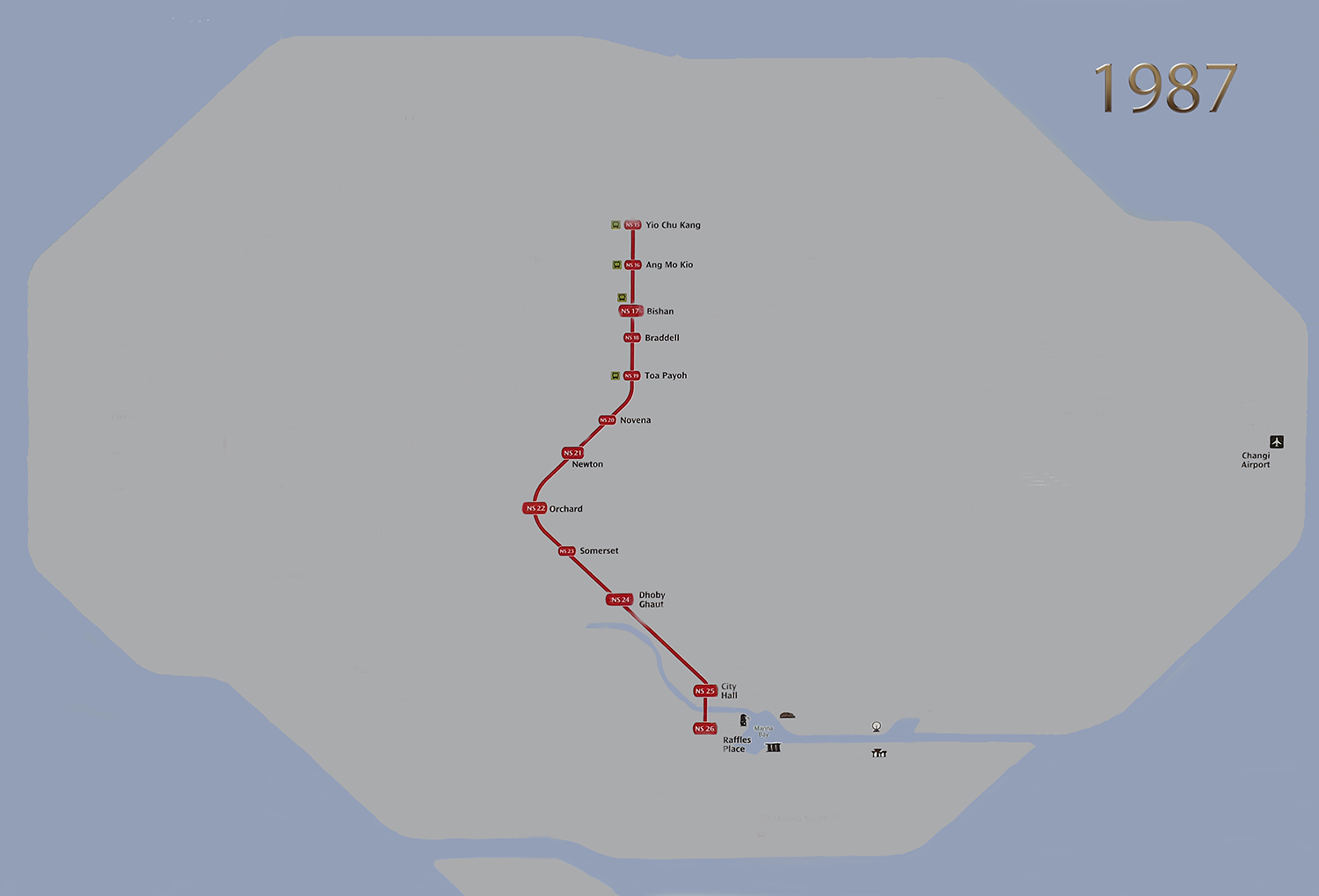
It all started in the 60’s when the Singapore Government decided to study the feasibility of having heavy rail transport. It took several years to work through the details and in the early 80’s a first plan was formulated for two lines to be built from the suburbs to the Central Business District (or CBD). The first stretch of MRT (phase 1) was opened on 7 November 1987. It covered 6 km and had 5 stations: Yio Chu Kang, Ang Mo Kio, Bishan, Braddell and Toa Payoh, in an area where there are a lot of HDB complexes (HDB’s are built by the government in order to provide affordable housing for all Singaporeans).

The network rapidly expanded and on 12 December 1987 (phase 2), 7 more stations were added to the North-South line: Novena, Newton, Orchard, Somerset, Dhoby Ghaut, City Hall and Raffle’s Place.
1988 introduced three more phases: phase 3 on 12 March, phase 4 on 5 November and phase 5 on 20 December.
Phases 3 and 4 added the first stretch of the East-West line from Lakeside to City Hall, with the first two interchange stations – City Hall and Raffle’s Place.
Phase 5 extended the North-South line all the way to Yishun, 2 additional stations.
At the end of 1988, there are 2 MRT lines and 25 operational MRT Stations.
Please note: a lot of the photos below show a “Before” and “After” situation with a slider that allows you to alternate between the two and see where the changes occur – have some fun with it s it took me forever to figure out how to do this, only to find out that WordPress has an easy plugin called Twenty20 that only creates this type of images.

Phase 6 (4 November 1989) and 7 (16 December 1989) extended the East-West line all the way to Pasir Ris (12 new stations) and added Marina Bay to the North-South line
The last phases of the initial plan were completed in 1990, two years ahead of the initial schedule. A branch line from Jurong East to Choa Chu Kang was opened on 10 March and the East-West line was extended to Boon Lay (one more station) on 6 July. There are now 42 MRT stations.
This completed the first planned MRT and other than minor expansions, the system remained essentially the same for 13 years.

On 19 February 1996, the section of the North South line from Yishun to Choa Chu Kang was opened, closing the loop to Jurong East. I was surprised to read that as I came to Singapore in June of 1996 and I was convinced that the connection was not there yet, but I must remember wrong.
So this is what the networked looked like the first time I came to Singapore.

Over the next six years, there are incremental changes only.
The first LRT was added in 1999 in Chao Chu Kang; The East West line was extended first to Expo and later the Changi Airport; the Dover station was added to the East West line.
Here is how the network evolved in those 6 years and what is looked like at the end of 2002

2003 saw the first new line: The North East line from Punggol to HarbourFront. Three LRT loops were also added, 2 at Sengkang and one at Punggol. A significant portion of the island (and the current population) is now served by an MRT. By 2006, this is what the network looked like.

From 2009 to 2012, the forth line is built in three stages. It is aptly named the circle line and will eventually make a full circle around the center of Singapore.
Woodleigh station is added to the North East line and Pioneer and Joo Koon are added to the East West line.
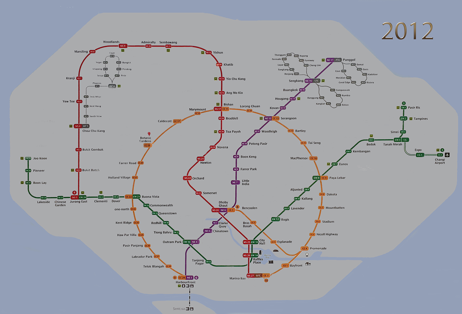
Between 2013 and 2017, the Downtown line appears. Over the same period, the West loop pf the Punggol LRT is added, the East West line is extended to Tuas Link and in 2019 Canberra Station is added to the North South line

The latest addition to the network is the Tomson-East Coast Line which opened a first segment on 31 January 2020 with just three stations in the woodlands area
Stage 2 opened 6 more stations on 28 August 2021 and the line currently runs from Caldecott to Woodlands North, connecting to both the Circle Line and the North-South line.
Further progress on this line has been delayed by the COVID-19 Pandemic and the third phase which was planned initially in 2021 has been postponed several times. Construction is now completed and the system is being tested before the line can be put in service. This is a very important steps. All MRT lines in Singapore are fully automated and have no drivers. The East West line and the North South line initially had drivers but were retrofitted to fully automated in the 2010’s. It is important to know the system works well and reliably before passengers are allowed.
Stage 3, now expected for the end of 2022, will extend the line from Caldecott all the way to the CBD and Marina Bay. That section of line is not on the map at the beginning showing the “current” situation.
There are further expansion stages planned for the Tomson-East Coast line in 2024 and 2025 that will eventually extend the line all the way to Sungei Bedok, connecting with the Northern end of the Downtown Line. This will finally provide MRT access to the East Coast Park, a very popular destination for Singaporeans and visitors (it also has one of my favorite restaurants); today, only one bus goes there and therefore it is not very convenient without a car.
The Northern end of the Thomson-East Coast line at Woodlands North is expected to connect with the Johor Bahru-Singapore Rapid Transit System that will provide easy access to Johor Bahru and the rest of Malaysia.
The Circle line will be completed in 2026 with the section from Marina Bay to HarbourFront.
Further into the future, two more lines are on the drawing boards but without firm routing (It must be getting difficult to find place underground to still add more tunnels!)
The Jurong Region Line (light blue) will provide enhanced transportation on the West side of the current North South line and is expected in 2027-2029
The Cross Island line (light green) will go East to West in the middle of the island and is expected in 2030+
Here is a very good graphic from the LTA about the plans – it is 2 years old, so some of these have already been implemented.
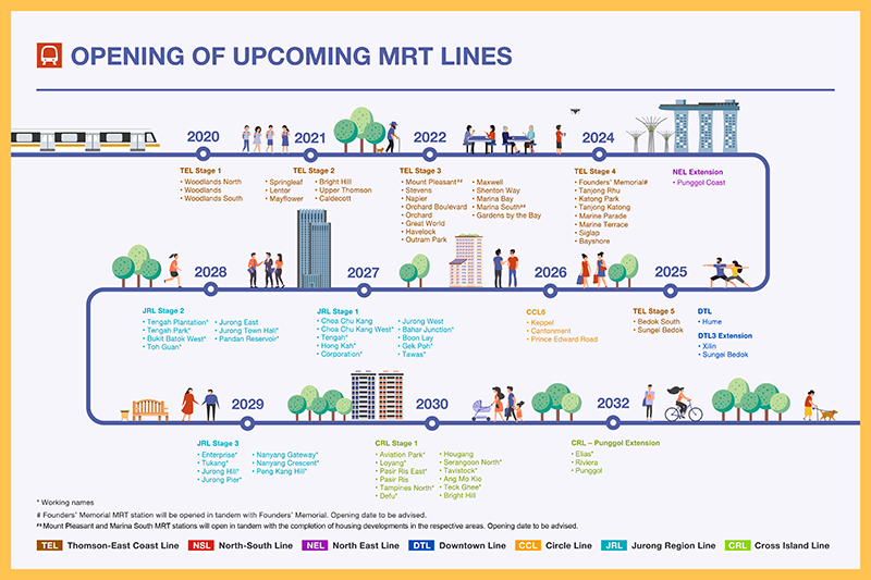
Here is what all this would look like on top of the existing network.

Based on what I have seen before, there are very good chances all of this will happen in the next few years. Time will tell how closely reality will match with this very rough representation.
To put all this into even better perspective, it is necessary to superimpose the actual lines on a scale map of Singapore. I decided to use Google Maps as a starting point. However, in order to have the MRT stations displayed on Google Maps, I needed to go to a very large scale, which means that I could only copy a very small section of the island each time. I took about 70 different sections of the map which I then stitched together manually to make the whole map. This resulted in a 10000 x 5000 pixel map, about 16 Mb. With that, I could then trace each line from station to station to show where they actually run. In order to add it to and display it on my blog, I had to reduce the size of the file, so this is the smaller version:

This gives a very good idea of the density of coverage in some areas, but also shows that other areas are still not very well served with MRT lines. The most glaring to me is the East Coast which is also very densely populated. It should have its own line rather soon as the Tomson-East Coast line will be extended to that area in 2024. Maybe in 2-3 years I will need to revisit this post and add the latest developments to it.
Now for the credits:
Of course, as already indicated, I stitched together almost 70 sections taken from Google Maps to make my large Singapore MRT Map
For the timing of development of the various lines. I used this site which also has a great interactive map of the whole network with a lot of information about stations, trains, depots and future plans:
https://mrtmapsingapore.com/
I used extensively Wikipedia to get history and information about the MRT, LRT and also individual stations. The two main sites I used are:
https://en.wikipedia.org/wiki/Mass_Rapid_Transit_(Singapore)
https://en.wikipedia.org/wiki/Light_Rail_Transit_(Singapore)
There are also very good descriptions in the Singapore Government’s Land Transport Authority website:
https://www.lta.gov.sg/content/ltagov/en/getting_around/public_transport/rail_network.html
All of the map representations I made myself using Photoshop Elements. I started with a photo I took in an MRT station of the current network which I enhanced to make editing easier. Then starting from the latest map, I gradually went back in time erasing each of the new developments until I arrived at the very first map in 1987. Therefore all maps and photos belong to me and can only be used, as such, with my permission.
(92 Page Views)
Your story is unusual and very interesting Pierre. Are you going to publish it ? ??
You may be interested,that my heat transfer professor and thesis advisor had a similar approach. He traveled from NYU’s Engineering campus in the Bronx to his home in the City.
His calculations showed that it was a lot less expensive to take taxis/trains or rent a car for trips. Plus he saved the high cost of parking in New York and had free time whilst somebody else Chauffeured.